Holyland Updates
Berisi tentang informasi terbaru dari Holyland khususnya Israel yang berhubungan dengan alkitab, informasi diambil dari beberapa sumber yaitu Bible Places Blog dan Biblical Arcaheological Review. Isi artikel dalam bahasa Inggris demi menjaga keotentikan berita.
Solving The Enigma Of Petra And The Nabatean
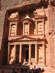
For every tourist who visits the ancient city of Petra in modern day Jordan, there is one breathtaking moment that captures all of the grandeur and mystery of this city carved in stone. After passing the final bend of the tortuous narrow canyon that leads into the site (the Siq), one is confronted by the awe-inspiring spectacle of a towering rock-cut façade, its sun-struck sandstone gleaming through the darkness of the canyon.
The façade, popularly known as the Khazneh, or “Treasury,” appears first only as a faint vision, its architectural details and full dimensions crowded out by the darkened walls of the Siq. But as you leave the Siq and enter the large open courtyard that sits before the Khazneh, you begin to realize, with astonishment and wonder, the immensity of the monument that towers above you.
The Khazneh is both unexpectedly familiar, and at the same time, strangely exotic. Its ornamented face is adorned with the columns, capitals and pediments of classical Western architecture, yet it seems entirely out of place in the rugged desert landscape of southern Jordan, an area historically inhabited by flock-tending Bedouin and simple farmers. Perhaps it was this bewildering juxtaposition that made the Khazneh the ideal backdrop for the climactic scene of the 1989 film Indiana Jones and the Last Crusade.
In many ways, the Khazneh epitomizes the complex character and competing ambitions of the Nabataeans, the industrious Arab people who built the city of Petra and its towering rock-cut monuments (including the Khazneh) over 2,000 years ago. Almost everything about the Nabataeans—their history, their culture, their religion, their technologies and especially their architecture—reflect a society born out of two worlds: one authentically Arabian, and the other unquestionably Hellenized.
The Nabataeans arose from humble nomadic origins in the vast deserts of northern Arabia sometime during the Persian period (539-332 B.C.). By the late fourth century B.C., they had established themselves in the area around Petra (or Reqem, as it was known to them), but they still maintained a largely nomadic existence, moving seasonally across the desert with their tents and herds in search of water and fresh pasture.
But it was also about this time that the Nabataeans began to get involved in the lucrative trade in South Arabian frankincense and myrrh, the same business that had led the Queen of Sheba to visit the court of Solomon some five centuries earlier (1 Kings 10). At first, the Nabataeans were little more than middlemen in the trade, simply responsible for ferrying goods on camelback from Petra to the ports of Gaza and Alexandria on the Mediterranean coast. But as their economic and political fortunes improved in the ensuing centuries, the Nabataeans gained political control over all of the lands bordering the Arabian frontier, a vast territory stretching from Damascus in the north to Hegra in the south.
By the first century B.C., Petra had become a full-fledged capital city, its rulers raking in considerable profits from an international spice trade that now extended from India to Rome. With such wealth and position, the Nabataean kings had to present both themselves and their city as equal partners in the international community, which at the time meant adopting the styles, tastes and the mores of “western” Hellenistic civilization. Petra, much like Jerusalem under the Herodian dynasty, was to be built as a first-order Greco-Roman city ruled by western-looking kings.
Indeed, the distinctly Hellenized flavor of Petra is patently obvious to any visitor to the site, even beyond the ornate façade of the Khazneh. Just a half-mile beyond the Treasury, one finds the well-worn but still very impressive remains of a Greco-Roman style theater, its multi-tiered seating not built but rather carved directly from Petra’s rose-colored sandstone bedrock. From the theater’s seats, one can just catch a glimpse of the elaborate, Hellenistic rock-cut façades of the Royal Tombs, thought to be the final resting places of the Nabataean kings and queens.
After a short hike beyond the theater, one comes to the heart of ancient Petra: a wide, half-mile long, stone-paved thoroughfare flanked on all sides by the key institutions of the city’s Hellenistic life. On the left, one can spot the remnants of luxurious pools and gardens, as well as a bustling market and a grand temple reached by a monumental staircase; to the right, there is an elegant nymphaeum and an opulent shrine dedicated to al-Uzza, one of the chief goddesses of the Nabataeans.
Further down the avenue, beyond the remains of a towering triumphal gate, stands the imposing edifice of Petra’s main temple, known today as Qasr al-Bint. With its walls preserved to a height of over 75 feet, Qasr al-Bint was built in the guise of a traditional Roman temple, with a broad colonnaded porch leading to a smaller interior shrine, or Holy of Holies. It was likely built in honor of the chief Nabataean god Dushara. Some distance behind this temple, on a hill overlooking the city’s main street, archaeologists have uncovered Petra’s high-rent district (known today as Zantur), where wealthy citizens owned villas adorned with colorful Pompeian-style frescoes and supplied with the finest local and imported wares.
Beyond the city center, however, the Hellenistic flavor of Petra gives way to monuments and features that are directly born of the Nabataeans’ nomadic and Arabian origins. A rigorous climb up Jabal al-Madhbah behind the Roman theater, for example, brings you to an open-air sanctuary topped by towering obelisks that was set aside for religious sacrifices and rituals. A similar open-air sanctuary has been found atop neighboring Jebel al-Khubtha to the east. Both sites, in addition to providing stunning views over the heart of ancient Petra and its intricate honeycomb of rock-cut tombs, highlight the importance of traditional high-place sanctuaries within Nabataean society.
One also finds depictions of rectangular stone blocks, or betyls, carved in the stones and rock faces throughout Petra’s cavernous passageways. These typically unadorned blocks (though some have schematized facial features) are thought to be traditional representations of Nabataean deities. Simplicity and minimalism in building and decoration is characteristic of the Arabian aspects of Nabataean civilization. Even ad-Deir (“the Monastery”), Petra’s largest and most imposing rock rock-cut façade, located in the hills high above the city, shows an austere Arabian decorative scheme that belies its otherwise Hellenistic architectural style.
The Nabataeans also had to learn to harness the limited water resources of their desert capital. Throughout Petra, Nabataean engineers took advantage of every natural spring and every winter downpour to channel water where it was needed. They constructed aqueducts and piping systems that allowed water to flow across mountains, through gorges and into the temples, homes and gardens of Petra’s citizens. Walking through the Siq, one can easily spot the remains of channels that directed water to the city center, as well as durable retention dams that kept powerful flood waters at bay.
But the apogee of this prosperous desert capital that rivaled Herod’s Jerusalem was short lived. By 106 A.D., the kingdom of Nabataea had been swallowed by the Roman Empire. Although Petra continued to flourish for many years, its importance waned as the overland trade in South Arabian incense declined and the Roman imperial economy collapsed. The city, like much of southern Palestine, was then devastated by an earthquake in 363 A.D. Petra carried on and even saw the rise of a significant Christian community, but it never again attained its former glory.
Is Mt. Sinai in Saudi Arabia ?
Two treasure hunters stood on the top of Jebel al-Lawz thinking it was the real Mt. Sinai, the "Mountain of God". One was struck with fear because he thought he was trespassing on the "holiest place on earth". As he gulped down Gatorade and munched on M & M's, a sense of guilt overcame him because he had forged a letter from the king of Saudi Arabia in order to obtain a visa into the Kingdom (Cornuke and Halbrook 2000: 10, 11, 74, 77, 79; Blum 1998: 206). Should he have felt guilty for this deceit? Yes, what he did was illegal, and offended the honor of the Saudi Arabian people. Should he have been afraid because he was on the holy mountain of God (Ex. 19:12)? No, because he was standing on the wrong mountain. MT. SINAI IS NOT IN SAUDI ARABIA!
This article will examine four aspects of the question regarding whether or not Mt. Sinai is located in Saudi Arabia. First, the credibility of the claims will be questioned. Second, the false assumptions by the proponents of Jebel al-Lawz will be disputed. Third, the Biblical evidence will be discussed. Fourth, the archaeological evidence will be examined.
Mount Sinai was the destination of Moses and the Children of Israel after the Lord miraculously delivered them from the bondage of Egypt (Ex. 18:5). It was from this mountain that the Lord also gave the Ten Commandments to Moses and the people of Israel (Ex. 19:1-3, 11,18; 20:1-17). Here, too, the prophet Elijah found himself after his escape from wicked Queen Jezebel (I Kings 19).
Pilgrims, scholars and tourists have visited the traditional site, Jebel Musa (Arabic for the Mountain of Moses) for more than 1,600 years. In the early 4th century AD Eusebius of Caesarea placed Mt. Sinai in the southern Sinai Peninsula. When Egeria made a pilgrimage to the East between AD 381 and 384, she visited Jebel Musa as Mt. Sinai (Wilkinson 1981: 1, 18, 91-100). This impressive mountain located in the southern Sinai Peninsula is situated behind the Byzantine monastery of St. Catherine's built by Emperor Justinian in the middle of the sixth century AD (Tsafrir 1978:219).
It may come as a surprise to most people, but scholars have identified 13 different sites as the "real" Mount Sinai (Har-el 1983:2). I would agree with the proponents of the Jebel al-Lawz hypothesis that Jebel Musa, the traditional Mt. Sinai, or any other site in the southern Sinai Peninsula, could not be the real Mt. Sinai. Professor Har-el in his book, The Sinai Journeys, has argued very convincingly, against the southern Sinai theory (1983: 175-233).
Recently, six American treasure hunters have added a 14th mountain to the already long list of candidates for the real Mt. Sinai: Jebel al-Lawz.
Who's Who Among the Treasure Hunters
The idea of Mt. Sinai being in Midian (Saudi Arabia) is not new. Charles Beke suggested Mount Baggir, to the NE of the Gulf of Akaba, as the true location of Mt. Sinai in his book Sinai in Arabia and of Midian in 1878. Alois Musil (1926: 263,264, 269, 296-298) and H. Philby (1957: 222-224) identify Mt. Sinai / Horeb with Jebel al-Manifa, near Wadi al-Hrob, 20 kilometers north of 'Ajnuna (1926: 269, 297). A French scholar, Jean Koenig (1971), has added the volcanic peak of Hala'l bedr to the list.
The late Ron Wyatt, a certified registered nurse anesthetist (CRNA) turned treasure hunter, added a fourth Midian site, Jebel al-Lawz, to the list. He also claimed to have discovered Noah's Ark, Sodom and Gomorrah, the Red Sea crossing and some of Pharaoh's chariots, the Ark of the Covenant with the blood of Jesus on the mercy seat, and other spectacular archaeological discoveries. This list is enough to make any archaeologist green with envy! However, one of Wyatt's partners in his Saudi Arabian venture called it a "treasure hunt" (Fasold 1993b:4).
In 1978, Wyatt claimed to have discovered the Red Sea crossing at Newaba in the Gulf of Akaba (the eastern branch of the Red Sea) and some of "Pharaoh's chariot wheels." This led Wyatt to conclude that Mt. Sinai must be in Saudi Arabia. His candidate for Mt. Sinai was Jebel al-Lawz because it was the highest peak in the entire NW Saudi Arabian region (Noorbergen 1982: 157-174). In 1984, Ron Wyatt and his two sons illegally crossed the border of Jordan into Saudi Arabia to visit the site. They explored and photographed the area around Jebel al-Lawz. As they tried to get back across the border they were captured, their film confiscated, and were jailed for 78 days as Israeli spies. They were eventually released.
In April 1985, Wyatt returned to Saudi Arabia legally under the patronage of a certain Mr. Samran al-Motairy. This time he had a contract with Samran to split the take on any "commercial minerals" found by them on their treasure hunt (Fasold 1993b: 4-6; Blum 1998: 47). To help locate the gold, Wyatt convinced David Fasold, with his "molecular frequency generator" (MFG), into joining their expedition to search for the "gold of Exodus" (Blum 1998: 49-51). Fasold claims this device can detect various types of metal under the ground.
When one of Samran's workers discovered "a bracelet that glittered for all the world like the purest of gold" (Blum 1998: 58), they were arrested and charged with "robbing Saudi Arabia of its wealth from antiquity" which they claimed was a capital offense (Cornuke and Halbrook 2000: 218). When they were finally released, all their film and notes were confiscated, and they were made to promise they would never return to Saudi Arabia and never publish or talk about their findings (Blum 1998: 59; Williams 1990: 25).
Upon his return, Fasold told Jim Irwin, the Apollo 15 astronaut who walked on the moon. Irwin in turn put Fasold in touch with two other potential treasure hunters - Larry Williams, a commodity trader and part time treasure hunter, and Robert Cornuke, a former police officer and SWAT team member (Cornuke and Halbrook 2000: 218). Fasold told them about the location of Mt. Sinai and the gold from Egypt. Part of his material is reproduced in Williams' book (1990: 25, 209-211) as well as his own newsletters (1993a; 1993b). Before they began this venture, they consulted an unnamed university professor in California, who wishes his identity to remain a "deep dark secret" (Blum 1998: 108). He seemed to agree with this idea and encouraged them in their pursuit.
Williams and Cornuke journeyed to Saudi Arabia twice in the summer of 1988 as self-proclaimed "Adventurers of History" in search of Mt. Sinai and the "gold of Exodus." They returned to tell the tale (Williams 1990:10,23). Larry Williams wrote a book about their adventures entitled The Mountain of Moses, The Discovery of Mount Sinai (1990). It was later reprinted under the title The Mount Sinai Myth (1990).
Another author, Howard Blum also wrote a popular book entitled The Gold of Exodus: The Discovery of the True Mount Sinai (1998a) based on the adventures of these two treasure hunters. The book has some inconsistencies. For example, Ronald Hendel (1999: 54) points out that before Williams and Cornuke went to Saudi Arabia in the summer of 1988, they had a meeting with an unnamed Biblical scholar from southern California. During the course of the conversation the unnamed scholar mentioned an interview of Dr. Frank Moore Cross in the August 1992 edition of Bible Review (Blum 1998:120-122). Talk about getting an advance copy of a publication! How did this professor get a copy of a 1992 issue of Bible Review in 1988?! The book is excerpted in an article in the February 1998 issue of "Vanity Fair" (Bloom 1998b).
A video entitled; "The Search for the Real Mt. Sinai" (1998) is being distributed based on these books. According to the advertisement for the video, Hershel Shanks, the editor of Biblical Archaeology Review, endorsed this video by saying; "Jabal al Lawz is the most likely site for Mount Sinai."
A weak review of Blum's book and the video was given by Ronald Hendel in the July / August 1999 issue of Biblical Archaeology Review (pages 54, 56) in which he never adequately deals with the arguments set forth by Williams and Blum. A spirited response appeared in the November / December 1999 issue of the same magazine by Tom Beard, the producer of the video (pages 66, 67). Hershel Shanks also added a clarification of his endorsement. He said, "The quote attributed to me is accurate but incomplete. I went on to say that all identifications of Mt. Sinai are highly speculative. A good case has been made that it is somewhere in northwest Saudi Arabia, and Jebel al-Lawz is the highest point in this area" (page 67).
In the spring of 2000, Bob Cornuke came out with his book that recounts their adventures in Saudi Arabia. The book is entitled In Search of the Mountain of God with the subtitle "The discovery of the real Mt. Sinai" (Cornuke and Halbrook 2000). It is basically a retelling of his and Williams' adventures found in the other books, but it also has a section at the end of the book about their search for Pharaoh's chariots in the Gulf of Akaba. He has a tendency to embellish, just like Blum. For example, he claims the signs on the fence surrounding Jebel al-Lawz said, "No Trespassing Allowed. Violators Will Be Put to Death" (Cornuke and Halbrook 2000: 1). Yet if one looks at the photograph in Blum's book, the sign actually says, "Archaeological area warning: It is unlawful to trespass. Violators are subject to penalties stipulated in the antiquities regulations passed by royal decree no. M 26, U 23.6.1392" (1998: plate 4, top). Williams (1990: 157) just mentions the fines, but not the death penalty.
The thesis of these books and video is that the real Mount Sinai is located at Jebel el-Lawz in Saudi Arabia, and the gold that the Israelites took from the Egyptians is in "them thar hills!" Are their views correct? The simple answer is no. There are a number of significant problems with this view. Mount Sinai is in the Sinai Peninsula right where the Bible places it.
Problems With This View
The biggest problem with the identification of Mt. Sinai at Jebel el-Lawz is that it does not meet the Biblical criteria for the site. These claims are based on three false assumptions and a misunderstanding of the archaeological remains that they observed. It is beyond the scope of this article to deal with the Red Sea crossing and the chronology of the Exodus from Egypt to Mt. Sinai. I will tackle these issues in a future issue of "Bible and Spade."
False Assumption #1: The Sinai Peninsula was considered the Land of Egypt
The first false assumption is that the Sinai Peninsula was within the territorial borders of the Land of Egypt. Over and over in his book, Williams (1990: 15-17, 22, 26) calls the Sinai Peninsula the "Egyptian Peninsula". If one looks at a modern Rand McNally Road map, the Sinai Peninsula is part of modern-day Egypt. However, 3,500 years ago, that was not the case.
The Bible says that once the Israelites left Succoth they were "out of Egypt" (Ex. 13: 18-20). The Land of Goshen was the eastern limits of the Land of Egypt. Apparently the fortresses on the Eastern Frontier Canal was the border between Egypt and the Sinai (Hoffmeier 1997: 164-175). Sir Flinders Petrie, the Father of Palestinian Archaeology, states that the copper and turquoise mines in Sinai were "in the desert outside the territorial border of Egypt, which passed to the east of the delta" (emphasis mine, cited in Williams 1990: 56). Ironically Williams missed the implication of this statement.
One gets the impression reading Williams, Blum and Cornuke that the Egyptians had year-round mining activities and a standing army all over Sinai (Williams 1990: 58). It is true there were turquoise mines at Serabit el-Khadem in southern Sinai (Beit-Arieh 1993:4:1335-1338). However, as Petrie (1906: viii, 169) points out, mining was seasonal, from January to April, so the Israelites would have found Sinai "quite empty" when they left Egypt. He concluded, "The argument that the Israelites would not have traveled down to the region of the Egyptian mines has no force whatever. The Egyptians never occupied that mining district with a garrison, but only sent expeditions; at the most these were in alternate years, and in the time of Merenptah only once in many years" (Petrie 1906: 206).
It is also true that there were Egyptian soldiers garrisoned in fortresses in Sinai. However, those fortresses were limited to northern Sinai. Alan Gardiner, a leading Egyptologist, did an important study from the Egyptian sources of the "Ways of Horus" across the northern Sinai (1920: 99-116). An extensive survey and some excavations were conducted between 1972 and 1982 along this road in northern Sinai. The excavator concluded, "The survey results enable us for the first time to delineate the course of the 'Ways of Horus' in accurate detail, and to reconstruct the history of settlement and the degree of Egyptian activity on the land bridge between the Delta and southern Canaan" (Oren 1987: 76). One can understand why "God did not lead them [the Children of Israel] by the way of the land of the Philistines [another name for the 'Ways of Horus'], although that was near; for God said, 'Lest perhaps the people change their minds when they see war [with the Egyptian garrisons], and return to Egypt'" (Ex. 13: 17; NKJV; the parenthetical statements are the author's). This verse also places the Sinai Peninsula outside the Land of Egypt. If the Children of Israel saw war with the Egyptian garrisons on the Ways of Horus in the Sinai Peninsula, they would return to Egypt. The Sinai was outside the Land of Egypt.
Another archaeologist who excavated extensively in Sinai, observed, "ancient Egyptian hegemony never extended into south central Sinai. The Egyptians did reach the western strip of southern Sinai, where they worked the turquoise mines of Serabit el-Khadem and similar mines at nearby Wadi Maghara. But despite the fact that south central Sinai contains copper deposits that were highly prized in ancient times, there is no evidence to indicate that the Egyptians were active in the exploitation of these copper deposits" (Beit-Arieh 1988: 36).
Williams (1990: 57,58) and others wonder how the Israelites could wander in the Sinai Peninsula for 40 years without running into the Egyptians. As noted above, there were some parts of Sinai that did not have any Egyptians. It should also be kept in mind what happened at the Red Sea. Pharaoh's elite force of 600 chariots and all his other chariots (Ex. 14:7, 9, 23-30; Josephus says that there was an additional 50,000 horsemen and 200,000 infantry, Antiquities 2:324, LCL 4: 307) were destroyed when the Red Sea collapsed on them (Ex. 14:23-30; 15:4,5).
As a result, Israel "feared and believed" the LORD (Ex. 14: 31). The Philistines, Edomites, Moabites, and Canaanites were afraid and trembled (Ex. 15:14-16; Josh. 2: 10). If there were any military units left in Sinai, either from an expedition to the turquoise mines in Southern Sinai or guarding the "Ways of Horus" in Northern Sinai, what Egyptian military commander in his right mind would want to confront Israel?! They understood Moses' statement that the LORD was a "Man of War" and He was an awesome and powerful God (Ex. 15: 3,6,7; if. 14:25 NKJV).
Cornuke raises the problem of the lack of archaeological evidence for Israel in Sinai. After citing Beit-Arieh's 1984 article in Biblical Archaeology Review, he says, "Fifteen years of exhaustive, painstaking investigation by veteran archaeologists found nothing to suggest as many as two-and-a-half million Jewish pilgrims once flooded the Egyptian landscape. No trace of a mighty host littering the wilderness with their smoking campfires, stores of food, cook pots, and acres of pottery, ceremonial implements and utensils, weapons, jewels, trinkets, and religious objects. No evidence of huge herds, flocks, or the daily waste and abandoned junk of a wandering multitude. Nothing" (Cornuke and Halbrook 2000: 168).
In another article, Dr. Beit-Arieh (1988: 37) reiterates the problem: "Nowhere have we found any material remains of human occupation at the time (Late Bronze Age 1550 1200 BC) when the Exodus is supposed to have occurred". He continues with a plausible solution to the problem, although I do not think he believes it: "Perhaps it will be argued, by those who subscribe to the traditional account in the Bible, that the Israelite material culture was only of the flimsiest kind and left no trace. Presumably the Israelite dwellings and artifacts consisted only of perishable materials" (Beit-Arieh 1988: 37).
The above results are understandable under "normal" conditions. Perhaps Cornuke did not consider that when the Israelites left Egypt, they had their kneading bowls (probably made of wood); the clothes on their back and any other clothes the Egyptians gave them. They also asked for, and received, gold and silver (Ex. 3: 21,22; 11: 2,3; 12: 34,35). Josephus adds that they received vessels of brass, which were used for their manna, metals, woven fabrics, decorations for armor, beasts of burden, and military implements (Antiquities of the Jews 3: 57; LCL 4: 347).
The armor they picked up after the Egyptians drowned in the Red Sea (Antiquities of the Jews 3: 59; LCL 4: 347). They dwelt in tents made from goat hair, not buildings. They also had the promise of God that their clothes and sandals would not wear out (Deut. 8: 4; 29: 5,6). Most of the articles were perishable and those metal objects were closely guarded because of their value. Most likely the Israelites left their pottery in Egypt because they knew it would break so they used the brass given to them by the Egyptians. They would have had no personal religious articles because that would be idolatry.
Due to the above factors, it is understandable that one would not expect to find archaeological remains.
In summary, Egypt exploited the natural resources of Sinai and controlled certain roads in the northern part of the peninsula, but it was not within the borders of the Land of Egypt.
St. Catherine's Monastery at the base of Jebel Musa, the traditional location of Mt. Sinai. It was founded as both a monastic center and a pilgrimage site. The basilica Church of Justinian inside the compound was built between 548 and 565. In addition to the functional buildings, a "burning bush" and "well of Moses" are located within the walls of the monastery.
False Assumption #2: Mt. Sinai is in the Land of Midian
The second false assumption is that Mt. Sinai is located in the Land of Midian, which is identified as part of the Saudi Arabian peninsula (Williams 1990:68-74).
I would agree with the proponents of Jebel al-Lawz that Midian is in the area of northwestern Saudi Arabia today. I think most scholars would attest to that (Parr 1989: 39-66; 1996: 213-218). However, the Biblical text does not place Mt. Sinai in the Land of Midian.
In an interview with Hershel Shanks, Prof. Frank Moore Cross, retired professor of Hebrew at Harvard University opines that the mountain of God was located in the Land of Midian. When asked if he had a guess what mountain might be Mt. Sinai, he responded, "I really don't. There are several enormous mountains in what is now northwestern Saudi Arabia. Jebel el-Lawz is the highest of the mountain in Midian 8,465 feet higher than any mountain in the Sinai Peninsula; but biblical Mt. Sinai need not be the highest mountain. There is some reason to search for it in southern Edom, which was Midianite terrain before the expansion of the Edomites south" (Shanks 1992:32). He later put the "Midian Hypothesis" in print, but did not endorse any mountains for the location of Mt. Sinai (Cross 1998: 60-68). Yet the question is still remains, Is Mt. Sinai in Midian?
The assumption that Mt. Sinai is in Midian is based on Ex. 3:1. As Cross (1998: 61) says, "This text presumes that the mountain is in Midian territory". It would be assumed that because Moses kept Jethro's flock of sheep and Jethro was a Midianite. When it says "he led the flock to the back of the desert, and came to Horeb, the mountain of God," the mountain of God must be in Midian. Williams (1990: 58) also states that Moses tended Jethro's flock at Mt. Sinai for 40 years. First of all, it should be pointed out that the Bible, in this verse, does not state that Moses tended the flock at Mt. Sinai for 40 years, nor does it explicitly state Mt. Horeb is in Midian. Second, I think a more plausible explanation of the geography can be given. (For a moment, permit me to assume that Mt. Sinai is outside the Land of Midian. Below I will demonstrate this from Scripture).
It is important to note the chronology and context of Ex. 3:1. In Ex. 2:23 the king of Egypt, who wanted to kill Moses 40 years earlier, died (Ex. 2:15; 4:19; if. Acts 7:23, 30). Moses, while tending the flock in Midian for most of the 40 years, heard of his death. A plausible scenario of how he heard about the death was from some frankincense caravan that was returning from Egypt to "South Arabia" (MacDonald 1995: 1357). The Children of Israel were groaning because of their bondage in Egypt and God remembered His covenant with Abraham, Isaac and Jacob (Ex. 2:23-25). Moses, who had a concern for his family (Ex. 4:18) and a heart for the children of Israel, wanted to learn more about what was going on. He took Jethro's flock to Mt. Sinai (we will assume Mt. Sinai is located at Jebel Sin Bishar in western central Sinai. This region had good pastureland and was well-watered (Har-el 1983: 425]).
It is not unusual for Bedouin shepherds to go long distances to find pasture for their flocks. I have met Bedouin shepherds who come from the Beersheva region with their flocks north of Jerusalem, a distance of over 70 miles. What better cover could Moses want than being an old shepherd tending his sheep? Moses left Egypt as a 40-year-old Egyptian administrator, most likely clean-shaven and bald . Now he was returning as an 80-year-old man, probably with a beard and white hair! (At least that's what Charlton Heston looked like in "The Ten Commandments")! Nobody would recognize him after 40 years of being away (contra Williams 1990: 59). The Angel of the LORD, however, knew who he was and appeared to him in a burning bush (Ex. 3:2 4:17). Moses returned to Jethro (in Midian) and asked his permission to return to Egypt after being away for 40 years (Ex. 4:18). Jethro granted him permission and Moses set out toward Egypt. The Lord instructed Aaron to meet his brother at the mountain of God (Ex. 4:27). The impression from the text is that Moses was almost back to Egypt when he met Aaron and not Aaron traveling all the way to Midian to meet Moses.
If one looks at the Bible carefully, it will be observed that Mt. Sinai is outside the Land of Midian. Two verses demonstrate this placement. The first is found in Exodus 18. In the context, Moses and the Children of Israel are camped at "the Mountain of God" (Mt. Sinai). Jethro, the father-in-law of Moses, brings his family to visit with Moses. During the course of their stay, Jethro gives Moses some invaluable advice about governing the people. In verse 27, it states, "Then Moses let his father-in-law depart [from Mt. Sinai], and he went his way to his own land [Midian]" (NKJV, parenthetical statements added by the author). Jethro departs from Mt. Sinai to return to his own land of Midian.
The second verse that places Mt. Sinai outside the Land of Midian is found in Numbers 10. In the context, the Children of Israel are getting ready to depart from Mt. Sinai and Moses invites his brother-in-law, Hobab, to join them in going to the Promised Land (10:29). Hobab responds, "I will not go, but I will depart [from Mt. Sinai] to my own land [Midian] and to my kinsmen" (10:30). Williams (1990: 73) misses the point of this passage. He says Hobab is telling Moses "that he has no desire to leave his homeland of Midian". Williams is assuming that Mt. Sinai is in Midian. If that were the case, Hobab would have said, "I will not depart, but stay in my own land and with my kinsmen." However, the text is saying Hobab wants to return to his own land, the place of his birth (Midian), which can only be done by departing from Mt. Sinai, because it is outside his homeland. [My thanks to Prof. Faiman for pointing these two verses out to me. Har-el also makes this point (1983: 250)].
False Assumption #3: Galatians 4:25 says Mt. Sinai is in Saudi Arabia
The third false assumption is that the Apostle Paul says in Gal. 4:25 that Mt. Sinai was in Saudi Arabia.
Cornuke plainly states this when he says, "The apostle Paul, under the inspiration of the Holy Spirit, informs us that Mount Sinai is in Saudi Arabia. Not Egypt!" (Cornuke and Halbrook 2000: 171). The Bible says nothing of the sort. Granted, the Holy Spirit could have predicted the Kingdom of Saudi Arabia long before it came on the world scene. After all, He predicted Cyrus by name 210 years before he became king of Persia (Isa. 44:28; 45:1; Antiquities of the Jews 11: 5; LCL 6: 315). Yet all the Bible says is that Mount Sinai is in Arabia.
Moses never uses the word "Arab" or "Arabia" at the time he wrote the Pentateuch. The words appear later in the Bible (I Kings 10:15; II Chron. 9:14; 17:11; 21:16; 22:1; 26:7; Neh. 2:19; 4:7; 6:1; Isa. 13:20; 21:13; Jer. 3:2; 25:24; Ezek. 27:21). So the Apostle Paul does not have a Mosaic use of the word "Arabia" in mind when he uses the word in Gal. 4:25 because "Arabia" did not exist in Moses' day.
The Galatians 4:25 reference might indeed support the view that Mount Sinai was in Saudi Arabia if the Apostle Paul was looking at a 1990 Rand McNally Atlas. However, it would not be true if he was looking at a First Century AD Roman road map. Although no actual maps of Roman Arabia exist from this period, we do possess the accounts of the contemporary travelers such as Strabo, a Greek from Pontus (64 BC to ca. AD 25). He describes the borders of Arabia as having its eastern border at the Persian Gulf and its western border at the East Side of the Nile River. This means that Strabo understood the entire Arabian Peninsula and the Sinai Peninsula to be included in First Century Arabia (Geography 16:4:2; 17:1:21,24-26,30,31; LCL VII: 309; VIII: 71-79, 85-87).
The word "Arab" first appears in an extra-Biblical inscription from a monolith found at Kurkh from the time of Shalmaneser III (853 BC). Throughout the Assyrian period, various Assyrian kings describe the activities of the Arabs, or desert nomads.
The first time the word "Arabia" is used as a term for a designated geographical area is in the mid-fifth century BC by the famous Greek historian and traveler, Herodotus (born ca. 484 BC). He traveled to Egypt and wrote about his trip in his book, The Persian Wars. In his monumental work on ancient Arabs, Dr. Israel Eph'al of Tel Aviv University, points out that "Herodotus calls the entire region east of the Nile and the Pelusian Branch, from the Mediterranean to the Red Sea, 'Arabia', and its population 'Arabs' (2: 8, 15, 19, 30, 75, 124, 158)". (Eph'al 1982: 193).
"Now in Arabia, not far from Egypt, there is a gulf of the sea entering in from the sea called Red [the Gulf of Suez], of which the length and narrowness is such as I shall show." Herodotus, The Persian Wars 2:11; LCL I: 285,287.
Moreover, in the mid-third century BC, 72 Jewish scholars translated the Hebrew Bible into Greek (known as the Septuagint) and followed the contemporary use of the word "Arabia" when they referred to Goshen as "Goshen of Arabia" (Gen. 45:10; 46:34). While Goshen is clearly part of Egypt (Gen. 37:6, 27; Ex. 9:26), the translator imposed the third century BC geographical reality on their translation.
On Egeria's pilgrimage to the Holy Land, she visited Mt. Sinai (Jebel Musa) and also the Land of Goshen (Wilkinson 1981:91-103). In Goshen, she stayed at Clysma, a "city of Arabia" (Wilkinson 1981:100). She wrote, "It gets its name from the region, which is called 'the land of Arabia, the land of Goshen', a region which, while it is part of Egypt, is a great deal better than any of the rest" (1981:100,101). Egeria followed the Septuagint reading of Gen. 46:34 in her description of Goshen being in the Land of Arabia.
Therefore, when the Apostle Paul says that Mt. Sinai is in Arabia, he is using the First century AD understanding of the word. He would be perfectly correct in placing Mt. Sinai in the Sinai Peninsula because the Sinai Peninsula was part of Arabia in his day.
In conjunction with Galatians 4:25, three other verses have been used to demonstrate that Mt. Sinai was outside the Sinai Peninsula: Deuteronomy 33:2; Judges 5:4; and Habakkuk 3:3. It is stated that Seir, Mt. Paran and Teman are located in present day Jordan or even Saudi Arabia (Heiser 1998; Cross 1998).
Most scholars put the territory of Edom in the Transjordanian mountains to the east of the Aravah and northeast of the Gulf of Akaba. A careful examination of the Scriptures places it also on the west side of the Aravah (Num. 34: 3; Josh. 15:1). The area, called today the Central Negev Highlands, from the Wilderness of Zin and Kadesh Barnea, south to Eilat was also Edomite territory (Crew 1981: 121-151; Rasmussen 1989: 91; Meshel 2000: 104). If this were the case, the locations of Seir, Mt. Paran and Teman could be moved back into the Central Negev Highlands and northeast Sinai. A case can be made for Mt. Paran being in the area of Kadesh Barnea, known today as Ein Qudeirat (Num. 13: 26). Mt. Seir could be identified with the Jebel-es-Se'ira, 45 km to the west of Eilat and west of the Kadesh Barnea Eilat road (Har-el 1983: 338). Teman would be located in the area of Kuntillet 'Ajrud where the inscriptions with the name "Yahweh of Teman" were found (Meshel 1993). If these identifications are accepted, then these passages (Deut. 33:2; Judges 5:4; Habakkuk 3:3) refer to the Lord leading the Children of Israel by the pillar of fire through the northeastern part of the Sinai Peninsula for 40 years.
Eleven Days to Kadesh Barnea
Another major problem for the Jebel el-Lawz site is the statement by Moses that Mt. Horeb (another name for Mt. Sinai) is "eleven days journey from Kadesh Barnea" (Deut. 1:2). It would be impossible to march more than 2 million Israelites through the difficult terrain from Jebel el-Lawz to Kadesh Barnea in the allotted time. However, Wyatt, Williams, Blum and Cornuke all ignore this problem.
Biblical Kadesh Barnea has been located at Ein Qedis (the spring of Qedis), where the Arabic name preserves the Biblical name Kadesh, in NE Sinai. Others have placed it 10 km. to the northwest at the tel near Ein Qudeirat that has an Iron Age fortress on it. Ein Qudeirat is the richest spring in all of Sinai producing a flow of water at about 40 cubic meters per hour! (Dothan 1965: 134). In a popular article on his excavations at Kadesh Barnea, Rudolph Cohen (1981: 21) asks, "Has the site been correctly identified? If so, why have we found no remains from the Exodus period?" I believe the area is correctly identified and as suggested before, would not expect to find remains of the Israelites.
Others that place Mt. Sinai in Midian recognize the "eleven days" problem and place Kadesh Barnea near Petra. The problem with this identification is that the southern border of Israel goes from the Salt Sea (Dead Sea) to the Sea (Mediterranean Sea) via the Wilderness of Zin and Kadesh Barnea (Num. 34: 1-5; Josh. 15: 1-4). If Kadesh Barnea were in the area of Petra, then most of ancient Edom's territory would be in Biblical Israel! Geographically that does not make any sense.
Misunderstanding the Archaeological Evidence
Those who hold to the Jebel al-Lawz site as Mt. Sinai are quick to point out the "archaeological evidence". Their reasoning is, "Look what was found, everything fits, it must be the site"! Let's look at the evidence and see if it really "fits".
Survey of the area
Our treasure hunters write as if they were the first westerners to explore Jebel al-Lawz and the surrounding area to do "research" (Cornuke and Halbrook 2000: 2; Williams 1990: 101). Such is not the case.
In the early 1950's, Harry St. John Philby visited the region of Midian and surveyed sites in the area. His book, The Land of Midian was published in 1957, and "gives a detailed and reliable account of the topography of the country. Philby's descriptions of such ancient sites as he knew of and visited (such as Mugha'ir Shu'ayb, Rawwafah, and Qurayyah) are also, so far as they go, accurate and useful, but unfortunately his photographs are poor, and he did not publish any plans or any of the surface sherds and other antiquities which he diligently collected during his journeying" (Parr, et. al. 1968-1969: 194). Philby (1957: 209,215) viewed Jebel al-Lawz from a distance and observed a "patch of snow" at the summit, but did not visit the mountain.
Parr continues: "Prior to Philby's explorations, the region had received a certain amount of attention from travelers and orientalists during the nineteenth and very early twentieth centuries. The early history of this activity has been recounted by Hogarth in The Penetration of Arabia (1904), and includes such names as Burckhart (1812), Ruppell (1826), Moresby and Wellsted (1831), Wallin (1848), Burton (1877), Doughty (1877/8), Huber (1878 and 1883) and Euting (1883). The construction of the Hejaz Railway between 1904 and 1908 made the area more accessible, and the opportunity to investigate was taken by such scholars as Jaussen and Savignac (1907-10), Moritz (1910), and Musil (1910)" (Parr et. al. 1968-1969: 196).
Williams laments that he tried to get information on Jebel al-Lawz and the caves at al-Bad' from people in Saudi Arabia. He claims that the government had not produced anything on these archaeological remains (1990: 183). As will be shown below, that is not the case either.
Mt. Sinai Covered with Smoke
Williams and Cornuke have pictures of the summit of Jebel al-Lawz "scorched black". Cornuke attributes this to the smoke that covered the mountain when the Lord came down on Mt. Sinai (Ex. 19: 16-20). He claims that the "blackened rock had become a holy handprint for the ages. God placed his signature in heavenly flames in a fashion so electrifying, so stupefying, that man's proud logic and science would be hard-pressed to explain it" (Cornuke and Halbrook 2000: 77). Williams (1990: 78) is a bit more cautious concerning this evidence.
Science may provide the answer. Cornuke (Cornuke and Halbrook 2000: 75) and Williams (1990: 167) brought back rocks for "future laboratory analysis". They arranged for geologists to look at their rock samples (Cornuke and Halbrook 2000: 116). Researchers are interested in seeing the lab analyses, but they have been unavailable for the last 13 years. Judgment on this evidence should be withheld until the rocks have been scientifically analyzed and properly published.
The Altar of the Golden Calf
The golden calf incident is recorded in Exodus 32 (see also Deut. 9:21). When Moses did not return from his trip to Mt. Sinai, the people requested Aaron make gods for them. He obliged them by taking their earrings and fashioning them into a molded calf. When he presented the calf he said, "This is your god, O Israel, that brought you out of the land of Egypt" (32:4). How soon he and the Children of Israel forgot the statement of the LORD that He brought them out of Egypt (Ex. 29:45,46)! The Bible says Aaron built an altar before the calf (Ex. 32:5).
Wyatt and Fasold found a huge pile of granite rocks in a plain about a quarter of a mile from the base of the mountain. On it, there were petroglyphs of bovine (bulls, cows and oxen) (Fasold 1993b: 8). Wyatt and Fasold claims that a Saudi archaeologist from Riyadh University said these were Egyptian-style cows and bulls, and that they had never been found anywhere else in Saudi Arabia (Williams 1990: 210, 211) . However, in a later article, Fasold (1993b: 12) does not mention the archaeologist's claim, but attributes the identification of the bovine as Hathor and Apis to Wyatt (Fasold 1993b: 8).
At Fasold's trial, the archaeologist that represented the Kingdom of Saudi Arabia allegedly said, "These drawings are the Hathor and Apis bull from Egypt I have never seen them in this country before" (Williams 1990: 106). No Saudi archaeologist would say such nonsense. They would be well aware of the surveys that had been done in the area and the unpublished petroglyphs. They know that bovine petroglyphs were found in the Midian area as well as other parts of the country (Livingstone et. al. 1985: 132-134; Plates 126, 127, 133; Nayeem 1990: 91, 92, 95). In all the archaeological literature that I read on rock art in Saudi Arabia, not once have I ever seen the word "Egyptian" connected with the bovine petroglyphs.
Cornuke wondered why bovine petroglyphs were found in this area. He reasoned: "This isn't cattle country. It is sheep country and had been for as long as men had walked these plains. Saudi Arabia has never been known for cattle unless, of course, they were driven here by the fleeing Israelites" (Cornuke and Halbrook 2000: 66). Williams makes similar statements as well (1990: 106).
What are we to make of this "evidence"? First, the Bible clearly states that Aaron, not the Children of Israel, made the altar before the golden calf (Ex. 32:5). I find it hard to believe that he could pick up these giant boulders and put them in place to make an altar! Cornuke believed that this "huge mound of stacked granite" (Cornuke and Halbrook 2000: 64) was built by "workers skilled in the art of building cities and moving mountains" (Cornuke and Halbrook 2000: 65). This view is contrary to the Scriptures. Aaron built the altar, not the Israelites.
Second, one Saudi archaeologist who did his doctoral thesis on Saudi Arabian rock art dates the "patched bovine" to the Neolithic period (Khan 1991: 115; plate 1). The Neolithic period is considerably earlier than the Late Bronze Age and the date of the Exodus from Egypt. Thus, it has nothing to do with the livestock the Israelites brought out of Egypt (Ex. 12: 38; 17:3; Num. 20:19; 32:1; Deut. 3:19).
Third, during the Neolithic period there was much more rainfall in Saudi Arabia than at the present (Ingraham 1981: 62). Thus there would be ample grazing places for cattle then. One does not have to make the assumption the Israelites drove the livestock to Saudi Arabia.
Fourth, let's assume for a minute that this was the site of the golden calf (However, I do not believe it is). Moses destroyed the golden calf because it was an idol. He would also have erased the petroglyphs of the bovine because they were graven images. Petroglyphs would be totally contrary to the Law that Moses had just received from the Lord on Mt. Sinai (Ex. 20:4). To answer Cornuke's question, "Had we really stumbled upon the altar of the golden calf?" (Cornuke and Halbrook 2000:67). The simple answer is no.
Cave of Moses
Some two kilometers south of the town of al-Bad' are caves called by the local people the caves of Moses and Jethro. Philby (1957: 214) records the local tradition at Bir al Saidni "as the very (well) from which Moses rolled away the stone to draw water for the flocks of Jethro's daughters" (if. Ex. 2:15-19). Cornuke (Cornuke and Halbrook 2000: 89-104; plate 13) and Williams (1990: 177-183; pictures 17-19) tell of their adventures in the al-Bad' area.
It should surprise no one that there are traditions that Moses and Jethro lived in the area, after all, this is in the Land of Midian (Ex. 2:15; Acts 7:29). The traditions stem from the fact that there were early Jewish traditions of them in the area (Kerkeslager 1998: 156-158), a Jewish community at the town of Makna to the southwest of al-Bad' on the coast in the 9th century AD (if. Acts 2: 11; Musil 1926: 114, 115) and the Moslem tradition that Moses was one of their prophets (Bosworth 1984). However, the interpretations that Williams and Cornuke put on these caves do not stand up to the facts. First, it is claimed that Moses and his family lived in these caves (Blum 1998a: plate 2; Cornuke and Halbrook 2000: 103). Second, Cornuke relates that the local tradition states that Jethro and Zipporah were buried in these caves based on some inscriptions found in them (Cornuke and Halbrook 2000: 99). Williams (1990: 192) reluctantly came to the conclusion that these were burial caves. Unfortunately they give no serious consideration to the dating of these burial caves. The closest they come is to Williams' (1990: picture 19) claims that they have "Egyptian fronts". What are the facts?
The region around al-Bad' as well as these caves have been explored, surveyed, photographed and published long before Williams and Cornuke ever visited the area (Musil 1926: 108-116; Philby 1957: 233, 257-262; Parr et. al. 1971: 30-35; plate 12-17). The caves are called "Magha'ir Shu'ayb" (the Caves of Jethro) and are in reality, Nabatean tombs dating to the 1st century AD. They are not Midianite tombs dating to the Late Bronze Age. The so-called "Egyptian front" is similar to what tourists see on the Nabatean tombs of Petra when they visit that site. As for the inscriptions, Musil (1926: 112) found five tombs with them but no mention of Moses, Jethro or Zipporah. Later, a British team of archaeologists resurveyed the tombs and found four inscriptions and published them, again saying nothing about Moses, Jethro or Zipporah (Parr, et. al. 1971: 32, 59). The caves are much later than the time of Moses and have nothing to do with the Exodus narratives.
The Altar of Moses and the 12 Pillars
The Bible says that Moses got up early one morning and built an altar at the base of the Mt. Sinai and set up twelve stone pillars representing the twelve tribes of Israel (Ex. 24: 4).
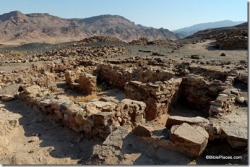
At the base of Jebel al-Lawz is an enigmatic stone structure. It is comprised pf three parallel V-shaped stone walls (Cornuke and Halbrook 2000: plate 11 top, 12 top). The Vs are at a 45 degree angle and measures 120 feet in length (Cornuke and Halbrook 2000: 86). This complex has been identified as an "angular stone altar" (ibid), trenches where they held the animals for sacrifice (Cornuke and Halbrook 2000: plate 12 top), or a temple (Williams 1990: 208, 211; Fasold 1993a: 10).
Dr. Majeed Kahn, a Saudi archaeologist who worked on the survey of the area, has informed me that these are the remains of the living quarters for the miners of a marble quarry in the area. The pottery collected at the site dates to the Nabatean period second century BC-first century AD). "White crude marble" pillars were prepared there and exported to Petra for the buildings in that city. These pillars are not to be identified as the 12 pillars representing the 12 tribes of Israel as Williams (1990: 212) claims.
Williams (1990: 97) states that the "local Bedouins tell us the stones had been removed to Haql for a temple or monument erected by Solomon or Sulliman". Fasold reported that some of the stones were removed in the 1930's to build a mosque in Haql (1993a:10). Elsewhere he says, "There was mention that the temple was put there by Sulliman, I think the name could have been Solomon" (Williams 1990: 211). In a later publication, Fasold reported that their Bedouin guide, Ibrahim, claimed Suleyman erected the temple. He then goes on to say, "It wasn't long before Ron [Wyatt] had the story elaborated into the temple being built by Solomon and Suleyman tearing it down to build the mosque, without a shred of evidence" (Fasold 1993a: 10). The only way the dating of this structure will be resolved is by an archaeological excavation.
To add some confusion to the finds in the area, Wyatt and Fasold found large circular structures some 18 feet in diameter in the immediate area (Williams 1990: 208-210; picture 3; Cornuke and Halbrook 2000: 124). Williams (1990: picture 3) says they are the 12 pillars representing the tribes of Israel, but Cornuke discounts that and says they are either ceremonial platforms or large cisterns (Cornuke and Halbrook 2000: 124). From the photographs and drawings, they look to me like the cairns, large stone circles probably connected with burials that are typical to the northwest Saudi Arabian area. The date and function of the cairns are unknown (Ingraham et. al. 1981: 69-71). Similar structures have been found elsewhere in the Levant. Mordechai Haiman, the excavator and surveyor of the cairn fields in the western Negev Highland in Israel, states that those cairns generally dated to the Early Bronze age "were not burial sites, but were probably used in a death ritual" (1992: 25). I would also place the so-called "boundary stones" (Ex. 19:12) in the same category (Williams 1990: 63; Cornuke and Halbrook 2000: 85,86; plate 10 bottom; Blum 1998: plate 6 bottom).
Dr. Khan informs me that a book on the rock art and archaeology of the al-Bad' area is in preparation by the Saudi Department of Archaeology. It will have a chapter on the archaeology of the Jebel al-Lawz area. We eagerly await this publication for a more definitive explanation of the archaeological remains.
The Split Rock at Horeb
Deuteronomy 9:21 says there is a "brook that descended from the mountain" into which Moses threw the gold dust from the golden calf. Cornuke and Williams found a large ravine that snakes down the mountain. Cornuke observed, "The ancient watershed a chalky, blister-dry remnant of a bygone wellspring was filled with large, water-polished boulders, clear evidence of a fast-rushing torrent. In a land that receives half an inch of rain per decade, it was proof that a stream of some magnitude had once caressed these rocks" (Cornuke and Halbrook 2000: 82). They also show a picture of a rock that is split 20 inches apart and suggest this is the rock the Moses struck (Ex. 17:2-6; Ps. 78: 15, 16, 20; 105:41; Cornuke 2000: plates 8 and 9).
Is this evidence of the split rock at Horeb? First, one should be cautious about making dogmatic statements based on photographs until a team of geologists is able to examine the rock closely. Second, Cornuke implies that the smooth rock was a result of the "river" flowing from the split rock because the area only gets a half-inch of rain per decade. While the area is classified as an arid desert, it does get 100 mm (4 inches) or less rain per year that comes in the form of tropical monsoons (Ingraham et. al. 1981: 62). In Philby's (1957: 205-228) account of his travels to the Midian Valley, he mentioned heavy rains and floods. Those people familiar with desert geology know that flash floods can provide the mechanism to polish the rocks (Cornuke and Halbrook 2000: plate 8, bottom).
Fasold's gold
One of the reasons the treasure hunters went to the mountain was to look for the gold and silver that the Children of Israel took from the Egyptians as they departed Egypt (Ex. 3:22; 11:2; 12:35,36). Fasold claims that his "molecular frequency generator" (MFG) produced readings that indicated the whole area was "loaded with buried gold the gold of the Exodus" (Blum 1998: 59). He also claims that his MFG device picked up gold readings in the area of the "golden calf altar" (Williams 1990: 107,108; Fasold 1993b: 8). Is this possible? Gold in this area should not surprise any geologist or archaeologist. The Land of Midian was noted for its gold mines! In 1982 (before the treasure hunters showed up), a survey was done in the Jebel al-Lawz area and two gold deposits were discovered. One at J. Maqda Ar Rahyat (site 200-1004), northwest of Jebel el-Lawz and another in the Wadi Maswat (site 200-1003), on the southwest slopes of the mountain (Kisnawi, et al. 1983: 82, plate 79). The surveyors indicate that one of the places gold is found is in alluvial deposits found in pits in the wadi (dry river bed). The miner just sifts the gravel or sand to find the gold (1983: 77). Fasold had set up his MFG device about 50 feet from the edge of the wadi (Blum 1998a: 53). Samran's workers were digging in the wadi when they allegedly discovered the "gold bracelet" (1998a: 58). One "bracelet" is insufficient evidence to claim that the gold of the Exodus is located at Jebel al-Lawz.
Why is the area fenced in?
The question has been raised, "If the area is not an important historical site, then why is it fenced in? What are they trying to prevent people from seeing?
In most countries, it is standard practice to fence in archaeological sites. There are at least four reasons why archaeologists fence in any given site. (1) To protect the sites from animals. In the case of Jebel al-Lawz they might be concerned about sheep and goats knocking down the walls of the "v-shaped altar". (2) To prevent military maneuvers from running over an archaeological site. (3) To protect the archaeological site from trespassers and vandals. (4) To prevent illegal excavations by treasure hunters. It seems reasonable to assume that the Saudi Department of Antiquities fenced in the sites after the first set of treasure hunters visited it because they were concerned others might follow. As it turned out, they were right.
The Saudis are also members of the International Council on Monuments and Sites (ICOMOS). This is an "international non-governmental organization of professionals, dedicated to the conservation of [the] world's historic monuments and sites."
To answer the questions raised above, the Saudis were protecting the sites and have nothing to hide. In fact, they should be commended for fencing in the sites to protect the world's historic sites and cultural heritage.
The Conclusion of the Matter
Contrary to their claims and the dust jacket endorsements that calls their evidence "overwhelming" and "scholarly" the case for Mt. Sinai in Saudi Arabia has not been made. The identification of Mt. Sinai in Saudi Arabia is not new. Other scholars and explorers have identified different mountains in Midian as Mt. Sinai and such identifications have long ago received proper scholarly assessment. For example, Dr. Menashe Har-el, one of Israel's leading geographers and an expert on the Sinai Peninsula, and for many years professor of Historical and Biblical Geography at Tel Aviv University, researched these questions several decades ago in his doctoral dissertation at New York University. He reworked his dissertation and published it under the title The Sinai Journeys, The Route of the Exodus. In this book, Har-el (1983: 242-275) spends a whole chapter refuting the idea that Mt. Sinai is in Midian (Saudi Arabia).
Professor Har-el also sets forth a very plausible alternative for the identification of Mt. Sinai. He proposed Mt. Sinai should be located at Jebel Sin Bishar in western central Sinai. This proposal is followed in the Zondervan NIV Atlas of the Bible (Rasmussen 1989: 88-90). In the next article, Professor David Faiman (1986, 1989, 1994) of Ben Gurion University of the Negev will discuss Har-el's proposal.
Simply stated, Mt. Sinai should be located in the Sinai Peninsula right where the Bible places it, not in Saudi Arabia.
Garden of Eden
Institute for Biblical and Scientific Studies
In order to locate Eden one must understand the ancient words being used. The "source" or "head" of the river is what we would call the "mouth" of the river (Hess & Tsumura, 1994, 178-9). Therefore all four rivers would empty into the Persian gulf. The Tigris and Euphrates rivers are easy to locate. Speiser identifies the possibilities of the other two as the Gihon=Diyala, Kirkha, or Kerkha and Psihon=Kerkha, Karun, or Wadi er-Rumma respectively (Ibid., 181, Map and more information at Lecture 3: Ancient Mesopotamia). If Gihon is identified with Kerkha, then the rivers of Eden are listed in an east to west direction, and the Pishon would be the Karun river in Elam. If Eridu may be equated with Eden then the Garden would be just east of Eridu where a branch canal produced abundant crops (Fischer 1996, 222). It should be noted that back then the Persian gulf would have been extended all the way back to Eridu and Ur.
There is another new identification of the river Pishon with the Wadi Batin that was seen from satellite photos. Wadi Batin is a dried up river, but at one time it would have connected with the Tigris and Euphrates Rivers. See Has the Garden of Eden been located at last? for photos and details. This is a very good possibility. The Gihon would then be identified with the Karun river in Elam.
Some think the Hebrew word "Eden" is from the Sumerian word "edin" meaning "plain" and its Akkadian equivalent is edinu (Fischer 1996, 223) which refers to the land between the Trigris and Euphrates Rivers.
Other scholars equate the garden of Eden with the similar description of ancient Dilmun. See Tombs of Dilmun . Dilum was probably the island Bahrain in the Persian gulf. There is a Sumerian story entitled Enki and Ninhursag which describes a paradise similar to Eden only it is called Dilmun. It says:
The land Dilmun is pure, the land Dilmun is clean; The land Dilmun is clean, the land Dilmun is most bright. In Dilmun the raven utters no cries, The ittidu-bird utters no the cry of the ittidu-bird, The lion kills not, The wolf snatches not the lamb, The sick-eyed says not "I am sick-eyed," The sick-headed (says) not "I am sick-headed," Its old woman (says) not "I am an old woman," Its old man (says) not "I am an old man," He filled the dikes with water, He filled the ditches with water, He filled the uncultivated places with water. The gardener in the dust in his joy (ANET 1969, 38-9).
The geography surrounding Eden seems to be the same before the flood as well as after the flood. The same rivers and mountains are mentioned. This seems to indicate that Noah’s flood was local. There is an excellent article on this by John Munday Jr entitled Eden’s Geography Erodes Flood Geology (Westminster Theological Journal 58:1. 123-44, 1996).
Searching for Sodom and Gomorrah
Biblical Archaeological Review - April 2009
Sodom and Gomorrah. They are perhaps the most infamous cities of the Bible, inhabited by men and women so vile and wicked that only their utter annihilation could appease God’s wrath (Genesis 19).
But where does the Bible locate these legendary dens of iniquity, and does any trace of them still exist?
It is clear from various Biblical passages that Sodom and Gomorrah should be located in the Dead Sea region. When Abraham and his nephew Lot part ways (Genesis 13:8-13), Lot chooses to settle in the Jordan valley “in the direction of Zoar” and moves his tents to “the cities of the plain” as far as Sodom. According to Genesis 14, the “cities of the plain,” which include Sodom, Gomorrah, Zoar, Zeboiim and Admah, join forces to battle a coalition of Mesopotamian kings in the “Valley of Siddim (that is, the Salt Sea),” a clear reference to the Dead Sea region. Another clue is found in Genesis 10:19, which describes the southern border of Canaan as extending east from Gaza “in the direction of Sodom, Gomorrah, Admah, and Zeboiim,” again placing the cities in the vicinity of the Dead Sea.
But Biblical scholars have long been divided about where exactly around the Dead Sea the cities were located. Most traditional theories place the cities at the southern end of the Dead Sea, in and around the well-watered and fertile plains and valleys south of the Lisan peninsula. At the southern end of this region, the Bible and other sources, including the first-century A.D. historian Josephus and the sixth-century A.D. Madaba Map, locate Zoar, one of the cities of the plain and the place to which Lot and his daughters fled following the destruction of Sodom (Genesis 19:22-23).*
Finding no clear archaeological evidence for Sodom and Gomorrah in the vicinity of Zoar, however, W.F. Albright and others conjectured that the remaining cities of the plain lay submerged beneath the shallow waters of the Dead Sea’s southern basin. They argued that during the time of Abraham, when the level of the Dead Sea was possibly much lower, the entire southern basin would have been a lush valley watered by rivers flowing down from the highlands of Moab.
By the late 1970s, when the level of the Dead Sea had begun to drop considerably due to industrial exploitation and damming projects, archaeologists had an unprecedented opportunity to search the now mostly dry southern basin for remains of the lost cities. But alas, not a sherd was found; there was no evidence that the cities had been submerged beneath the salt sea. While exploring the high fertile banks along the southeastern shore of the Dead Sea, however, the same archaeological expedition discovered the ruins of four towns that had been inhabited during the Early Bronze Age (3300-2000 B.C.).** Some scholars, though certainly not all,*** date the origins of the stories of Abraham and Lot to the end of this period.
The expedition, headed by archaeologists Thomas Schaub of Indiana University of Pennsylvania and Walter Rast of Valparaiso University, excavated two of the largest sites in the plain—Bab edh-Dhra and Numeira—and discovered that both had been thriving Bronze Age cities that were destroyed at almost exactly the same time, about 2350 B.C. Rast proposed that the Biblical story of the destruction of Sodom and Gomorrah originated from ancient traditions surrounding the near-simultaneous demise of these once-prosperous twin cities.
Although many have adopted Rast’s view of the southern provenance of the Sodom and Gomorrah tradition, others have proposed that the Bible actually locates the fabled cities at the northern end of the Dead Sea. The most vocal proponent of the northern theory is Dr. Steven Collins of Trinity Southwest University, who argues that Lot’s apportioned territory and all the “cities of the plain” (Genesis 13:8-13) should be located in the broad circular plain where the Jordan River meets the Dead Sea. First, according to Collins, Genesis 13 places the separation scene between Abraham and Lot somewhere around Ai and Bethel, an area that has commanding views over the northern Dead Sea and southern Jordan valley, not the southern Dead Sea region. Second, the passage describes Lot’s territory as the “circular” or “disc-shaped” plain (Heb. kikkar) of the Jordan, a term which Collins argues refers specifically to the broad alluvial plain of the southern Jordan valley just north of the Dead Sea. What is more, Collins believes he has located the actual site of Biblical Sodom on a high bank overlooking the valley. The site, Tell el-Hammam, is one of the largest mounds in the plain and supported almost continuous occupation from the Chalcolithic to the Byzantine period.
Although the site has substantial Early Bronze Age remains (as at Bab edh-Dhra and Numeira), Collins believes that the extensive and well-fortified Middle Bronze Age city (c. 2000-1550 B.C.) represents the Sodom known to Lot and Abraham, Biblical figures that he and many others believe should be dated to the first half of the second millennium B.C. In one area of the Middle Bronze Age city, Collins located a massive destruction layer over 3 feet thick. Could this layer be the archaeological residue of God’s infamous judgment on Sodom? Whatever the case, Collins hopes to uncover even more evidence of the Biblical story in future seasons of excavations at the site.
But whether one locates Sodom and Gomorrah south or north of the Dead Sea, there is plenty of reason to suspect that the Biblical tradition surrounding the doomed cities of the plain was more than just fanciful legend. As suggested by Amos Frumkin in his May/June 2009 BAR article on the salt pillar known as Lot’s Wife, the Sodom story told in the Bible likely represents an ancient memory of a single catastrophic event that affected the cities and peoples of the Dead Sea region nearly 4,000 years ago.
Sidebar: Explaining Sodom’s Destruction
The final destruction of Sodom and Gomorrah is vividly described in Genesis 19:24-25:
Then the Lord rained on Sodom and Gomorrah brimstone and fire from the Lord out of heaven; and he overthrew those cities, and all of the valley, and all the inhabitants of the cities, and what grew on the ground.
If the Biblical story does reflect a genuine historical memory of an ancient disaster in the Dead Sea region, what natural disaster would have brought about such a calamitous retelling?
As far back as the first-century A.D. historian Josephus, visitors to the Dead Sea have hypothesized about the nature of the catastrophe that “overthrew” the cities of the plain under a shower of brimstone and fire. For some, the explanation was a powerful flood that inundated the much shallower and then-dry southern basin of the Dead Sea. For others, the destruction was wrought by an ancient volcano that has become hidden and dormant in the centuries since. Some have even postulated that God’s fury was unleashed by a fiery ancient asteroid over a half-mile in diameter that destroyed everything in its path.
But the explanation that provides the most likely historical and geological context for the legendary destruction is a massive earthquake. The Dead Sea, part of the enormous geological fault line known as the Great Rift Valley, has been the epicenter of powerful earthquakes for countless millennia. Indeed, geologist Amos Frumkin believes that an earthquake measuring 8.0 on the Richter Scale gave rise to both the Sodom and Gomorrah tradition as well as the story surrounding the Mt. Sedom salt pillar (known as Lot’s Wife) some 4,000 years ago. Other scholars have proposed that the earthquake caused the narrow isthmus between the northern and southern Dead Sea basins to give way, which in turn flooded the southern “Valley of Siddim” and inundated the wicked cities and all their inhabitants.
Matching the earthquake theory to the Biblical conflagration, however, has required additional explanation. Most have proposed that the earthquake caused the natural sulfur and bitumen deposits of the Dead Sea area to erupt to the surface, thereby releasing large quantities of natural gas into the air. When exposed to fire—perhaps created by a lightning strike from above—the gas could have ignited and turned the entire plain into a huge furnace, consuming everything and everyone that could not escape.
Ancient City in Turkey Older Than Previously Thought
Biblical Archaeological Review - 3 November 2008
Izmir, the third most populous city in Turkey, may be older than previously thought. New archaeological excavations have revealed that the modern port city with ancient origins may be as old as 8,500 years. The head of the excavation team, Dr. Zafer Derin of Ege University, said in a written statement his team had removed 150 artifacts discovered at the Yesilova Tumulus excavation site that date to the Neolithic period. The recovered artifacts include spoons with religious motifs, as well as tools made of stone and bone. “Findings obtained from the excavation determined that those who lived in this area 8,500 years ago had an organized society and were related to the people who lived in Anatolia. We had clues that they also had commercial relations with people in the Anatolia region,” says Professor Derin.
The city is believed to be one of the oldest settlements in the Mediterranean basin. Today, it is Turkey’s second-largest port after Istanbul, and hosts a population of over 2.5 million people. Called “Smryna” until the early 20th century, the city was a key port location for the many ancient civilization that ruled over the territory at various points in history, such as the Greeks, the Romans, and the Ottoman Empire.
The Turkish Daily News reports on the new discoveries in Izmir, Turkey.
King Solomon’s Mine Discovered?
Biblical Archaeological Review - 29 October 2008
According to legend, King Solomon was the greatest ancient ruler of Israel, the builder of the First Temple, and the owner of mines that were filled with gold and diamonds. While some scholars have recently questioned the existence of King Solomon as well as his mythical mines, radiocarbon dates from an ancient copper smelting plant in Jordan have shed some new light on the debate. Located at the ancient site of Khirbat en-Nahas (“ruins of copper” in Arabic) approximately 30 miles south of the Dead Sea, the copper smelting facility has yielded radiocarbon dates from the 10th century B.C., which places it firmly within the traditional timeline of King Solomon.
Dr. Thomas Levy of the University of California, San Diego is the director of excavations at the site. He maintains that while the data does not necessarily prove the existence of King Solomon, it does demonstrate the existence of a complex society at that time; a hypothesis that some scholars have questioned given the dearth of archaeological evidence from this period. The site of Khirbat en-Nahas contains more than 100 buildings, including a fortress.
The LA Times reports on the ancient copper mine in Jordan.
Third Temple Preparations
Bible Places Blog - 19 October 2008
The Jerusalem Post has a long, but very good, article on the preparations being made for the construction of the Third Temple by the Temple Institute. If I had an extra couple of hours, I’d enjoy commenting on various statements made. Since I don’t, I’ll simply refer you to the article, which begins:
For centuries Jews have remembered and mourned the destruction of the Temple through traditions such as crushing a glass at weddings or leaving unpainted a patch of wall opposite the entrance to one's home - each stressing that nothing can be perfect or complete without the Temple.
Built by Solomon in about 950 BCE and destroyed by the Babylonians in 586 BCE, the Temple was rebuilt about 70 years later but finally razed by the Romans in 70 CE.
Talmud scholar Rabbi Yohanan wrote: "During these times that the Temple is demolished, a person is not allowed to fill his mouth with laughter. This is because the verse [Psalms 126] says, 'Then our mouths will be filled with laughter,' and does not say 'Now our mouths will be filled with laughter.' And when is 'then'? 'Then' will be when the Third Temple is rebuilt."
In other words, "Jewish life without the Temple is like fish out of water," says Rabbi Chaim Richman, head of the international department of the Temple Institute.
An author of 10 books on the Temple, Richman adds: "Do you realize that 202 commandments out of 613 must have the Temple to be fulfilled? Without the Temple, Judaism is a skeleton of what it's supposed to be."
To this end, the Temple Institute was founded in 1987 with the explicit goal of rebuilding the Temple. Located in the Jewish Quarter, some 100,000 visitors, about half of them Christian, visit the institute each year to learn about the First and Second Temples and preparations for the Third Temple.
The institute is presently involved in education, research and constructing vessels for use in the longed-for Temple.
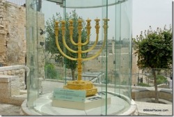
Picture message : Golden menorah, prepared for Third Temple. Estimated value: $3 million
You can read the full article here.
Pilgrim's Route in Jericho area
Bible Places Blog - 9 September 2008
Haaretz has a story on the new "Pilgrim's Route," select portions of which are below.
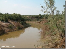
Some three million tourists are expected to visit Israel next year. And when they arrive, they will discover a new "Pilgrim's Route" leading from Jerusalem to the Dead Sea. Along the way, they will be able to visit the site where the New Testament story of the Good Samaritan took place; the Qumran caves; and the site where, according to the New Testament, John the Baptist baptized Jesus.
It is not clear what is meant by "Pilgrim's Route." Ideally, there will be a walking path along the ancient Roman road. More likely, there will be signs installed at each place designating it as part of the "Pilgrim's Route."
The Good Samaritan site is just off the highway leading from Jerusalem to the Dead Sea. During the Byzantine era, a church was built at that spot to commemorate the New Testament's tale of a man attacked by robbers while en route from Jerusalem to Jericho, who is refused help by all the passersby except the Good Samaritan. Archaeologists recently reconstructed the entire mosaic floor of the church.
It is unlikely that this site is anything more than a traditional place to remember the story. If there was an inn, it was probably in Jericho, not in the middle of the inhospitable wilderness. Furthermore, this may have been a story that Jesus created to teach a point and not a historical event (Luke 10:25-37).
Concerning the baptismal site:
According to Shai Weiner, the Tourism Ministry's deputy director general for economics, planning and infrastructure, the first stage of the site's development, which includes setting up shaded areas and making it wheelchair accessible, will be finished in about two months. The ministry has thus far invested some NIS 3.5 million in the site, and the Defense Ministry will invest about another NIS 1 million to improve the access road.
In addition to shaded areas, they need to get some of those amusement-park-type minster.
Weiner said that other Christian pilgrimage sites in Israel typically attract between 400,000 and 600,000 visitors a year, and he expects the same at this site. The ministry noted that the site would also jump start other businesses in the area, such as restaurants and souvenir shops.
Note to investors: buy stock in these new shops and sell your holdings in Yardenit.
Oni Amiel, CEO of Amiel Tours, which specializes in Christian pilgrims, said it is about time Israel began competing with the Jordanian site. "There's an enormous flow of tourists there," he said. "It's important that the site on our side also be respectable - and above all, that there be water in that dried-up Jordan."
So you get a flow of tourists where there once was a flow of water. Not such a good trade-off.
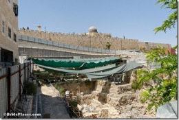
City of David Excavation Report
Bible Places Blog - 27 August 2008
Excavations began in the parking lot below Dung Gate in 2003 and were resumed in 2007. The Israel Antiquities Authority has just released a brief report on the discoveries from the 2007 season. It should be noted that this report does not include results from 2008.
The longest portion of the report concerns the Second Temple period, which is primarily the 1st century A.D. It reports one of the discoveries:
A large impressive edifice, whose northeastern corner has only been revealed to date, was in the southern unit. The eastern wall of the building (exposed length over 14 m, thickness c. 2 m, height more than 5 m) was built of large roughly dressed fieldstones, some of which were hundreds of kilograms in weight. The northern wall (width c. 1 m) was also preserved to a substantial height. The interior portion of the building, within the limits of the excavated area, indicated that the structure was divided into elongated halls, oriented northwest-southeast.
This is what was hailed in the media as the "palace of Queen Helene of Adiabene," though as the 1st century ruler's name is not mentioned in this report, some may have missed the connection.
The period of greater interest given the current discussion of the nature of Jerusalem in the Old Testament period is the section on the Iron Age, quoted here in full.
The remains of the period, exposed in five strata that represented most of the Iron Age, were founded directly on bedrock, marking the earliest settlement in this part of the City of David. This period was mainly characterized in this area by relatively densely built houses of careless and poor construction. The houses, built of one-stone-wide walls, contained a variety of domestic installations. These indicate a residential quarter that existed in the area during this period.
The early phase of the Iron Age was noted for the use of bedrock the builders had employed for setting the buildings’ walls and incorporating it within their built complex of structures. Thus, ‘habitation pockets’, confined between the buildings’ walls and bedrock outcrops, were discovered. This phase was dated earlier than the eighth century BCE, based on the abundance of ceramic finds. The later phase of this period dated to the seventh–sixth centuries BCE. No building remains from Iron I were discovered.
There are several significant points to note here:
The discovery of houses from the Iron Age in Jerusalem is unusual. In most places, later destruction removed traces of building except for monumental structure (walls, water systems). The best examples of houses were found on the other (that is, east) side of the City of David in Shiloh's excavation.
Caution should be taken before concluding that because some houses in Jerusalem at this time were of "poor construction," all were.
Some of the material is "earlier than the eighth century," which means 9th century (or possibly 10th, but distinguishing pottery between the two centuries is problematic at the moment). This indicates that there was habitation in this area before the expansion in Hezekiah's day (late 8th century) when the Western Hill was fortified. This should not be surprising, given indications in the biblical text.
That no remains were found from Iron I (or Bronze Age; see end of report) also fits the biblical narrative. The city of Jebus was small and more closely located to the Gihon Spring when it was captured by David. The city expanded to the north as David prepared for the construction of the temple.
In other words, the biblical account would lead us to expect to find remains earlier than the 10th century in the City of David, remains from the 10th century and later at the Temple Mount, with a likely "filling in" of habitation between the two sometime after the temple's construction. Admittedly, there are other possibilities, but this one seems quite reasonable, and it appears to fit with the results of this report.
Readers unfamiliar with the geography of the area and the location of these excavations will better understand the last two points with the graphic below, which shows that the excavation area was outside the boundaries of the "City of David."
A New Date for the Shroud of Turin?
Biblical Archaeological Review - 25 August 2008
The Shroud of Turin is believed by many to be the cloth that was wound around the body of Jesus in preparation for his burial, despite radiocarbon testing done in 1998 that indicated it was only about 700 years old. However, the long-venerated relic may have a second chance to be deemed authentic—or at least be determined to date from the same century as Jesus, whose imprint it is reputed to retain. Dr. John Jackson, a Colorado University physicist and leading expert on the Shroud, has won the support of an Oxford University laboratory for new carbon dating tests on the ancient cloth.
Dr. Jackson has argued that the presence of high levels of carbon monoxide could have skewed the 1988 tests results by as many as 1300 years. He maintains that other elements of the Shroud are much more ancient, and Oxford has agreed to work with Jackson in order to reassess the age of the cloth. So far, the Vatican has remained silent on the subject, saying only that the Shroud must not be touched as it will be put on public display at the Cathedral of St. John the Baptist in Turin in 2010.
The Times Online reports on a new date for the Shroud of Turin.
Conflict Over Upper Room Construction
Bible Places Blog - 22 August 2008
The Jerusalem Post reports on the legal dispute over the building next to the Upper Room.
An ancient monastery adjacent to where, according to Christian tradition, Jesus ate the Last Supper, has turned into a legal battleground for Catholics and Jews.
Last week the High Court of Justice issued a temporary restraining order halting construction work by a Jewish organization in a Franciscan monastery on Jerusalem's Mount Zion adjacent to the Cenaculum, the Latin term for the room where the Last Supper was held.
The court also issued an order preventing the Jewish organization - the Institute for the Study of the Family and Family Laws in Israel - from moving people in to live in the monastery, known as the Franciscan house, just outside the Dormition Church.
David Bartholdy, spokesman for Tancredi, a Catholic organization that petitioned the High Court, said the construction infringed on Christians' freedom of worship.
"This is a holy place for Christians of all denominations," Bartholdy said in a telephone interview with The Jerusalem Post on Thursday. "Work being done there is causing serious damage to a monastery with important historical and religious value. Construction workers have already uprooted ancient floor tiling, scraped off a layer of plaster from the walls, broken down antique, chiseled doors, and all this under the supervision of the Antiquities Authority.
"The construction work going on at the site raises the suspicion that someone is trying to Judaize a Catholic site and prevent freedom of religious expression."
The story continues here.
Tourism in East Jerusalem Up 28 Percent
Biblical Archaeological Review - 21 August 2008
Despite a flagging global economy and a drop in tourism worldwide, East Jerusalem has experienced a 28 percent growth in the number of visitors to historical sites so far in 2008. Gideon Shamir, the director general of the Company for the Development of East Jerusalem, reports that “More Israelis have rediscovered Jerusalem this year and they visit it more frequently than they used to do in the past.” Visitors from abroad have also increased in numbers, and are predicted to reach a record 2.8 million in 2008.
Long disputed over by Israeli and Palestinian authorities, Jerusalem has been subject to a number of terrorist attacks in recent years that have caused many tourists to steer clear of the city. Shamir attributes the growth in visitors to improved security in the area. In addition to security measures, improvements in facilities and services are also underway.
The Jerusalem Post reports on East Jerusalem’s rise in tourism.
Jerusalem Updates
Bible Places Blog - 20 August 2008
The excavations at Ramat Rahel are featured in a 3-minute video by infolive.tv. It begins:
Deep inside of the hills of Jerusalem rests the Kibbutz of Ramat Rachel. Over the past 50 years many archaeologists have realized that hidden beneath this kibbutz are archaeological treasures beyond one’s imagination - the ruins of the palace of one of the king of Judah, along with relics from the Persian, Hellenistic and Roman era. At this site where space and time are mixed within the earth, another hidden treasure long buried underground has recently resurfaced. Just a few days ago, 15 silver coins dating from the Second Temple period were discovered inside of an ancient pot hidden in a columbarium.
Jesus of Nazareth: Supernatural Athlete?
Biblical Archaeological Review - 16 August 2008
The historical figure of Jesus of Nazareth evokes many things for many people: prophet, philanthropist, mystic, and savior are just a few. But supernatural athlete? That’s a new one, and yet a just-published translation of an ancient manuscript suggests that he might have been just that. Dr. Abraham Terian, a recent visiting professor at the Hebrew University, cites the Armenian Gospel of the Infancy, an apocryphal document that was translated into Armenian in the 6th century from a much older lost Syriac original, as his source for this new account of the activities of the young Jesus.
The text describes a nine-year-old Jesus playing an early form of cricket with a club and a ball on the shores of the Sea of Galilee with other young boys. This in and of itself would not be unusual, as the concept of children playing is almost certainly as old as humanity itself. However, the ancient manuscript not only describes Jesus playing on the shores of the sea, but actually on top of the sea as if he was “playing on a frozen surface ... many would gather there and, watching him, would be amazed.” This text, says Terian, echoes the famous “walking on water” miracle described in the gospel accounts of John, Matthew, and Mark. But even more illuminating, according to Terian, is that fact that “even Jesus would forget work and would go have fun with the boys!”
The Daily Telegraph reports on Jesus playing an early form of cricket.
9,000-Year-Old Skulls Attest to Ancestor Worship
Biblical Archaeological Review - 15 August 2008
In a country as archaeologically rich as Israel, archaeological excavations are usually a routine part of any major construction project. Yet the recent discovery made by archaeologists at the Yiftah’el site in the Lower Galilee prior to the construction of a highway interchange was anything but routine. Three extraordinary skulls that are between 8,000-9,000 years old were recovered from a pit next to a large, mudbrick building of the same period. They are “sculpted” skulls—that is, skulls that were modified through the use of plaster and decorative items in order to create an image of the deceased.
Archaeological research has determined that within these communities the dead were generally buried in the floor of the buildings. After a certain amount of time had passed, the skulls were retrieved and the grave resealed with plaster. The skulls were then reconstructed with facial features. Evidence from contemporary sites indicate that these molded skulls were placed in small shrines within the dwelling of the living, perhaps as a way of inspiring the younger generation to carry on the traditions of their ancestors. A similar custom was also identified at sites in Syria, Turkey, and Jordan.
Israel National News reports on the discovery of the 9,000-year-old skulls.
4,000-Year-Old Grave of Canaanite Warrior Found
Biblical Archaeological Review - 6 August 2008
Excavators with the British Museum at Sidon, in southern Lebanon, have uncovered the tomb of young warrior buried with a spear. The tomb dates to 2000 B.C.; the skeleton is that of a 15-to-20-year-old. This is the seventy-seventh grave found by the team since it began excavations ten years ago. Earlier this year they discovered a jar, also from 2000 B.C., containing the remains of a newborn, while last year they found tons of wheat at the site.
Sidon is one of the most important sites in ancient Phoenicia and was, before that a key Canaanite city. It is mentioned 38 times in the Hebrew Bible. The Lebanese newspaper The Daily Star has a report on the young warrior’s tomb at Sidon.
Welcome to Genesis Land
Visitors to a tent encampment between Jerusalem and Jericho get a taste of life in Biblical times thanks to Israeli actors who portray Abraham and his faithful servant Eliezer. At Genesis Land modern four-wheeled modes of transportation are exchanged for the more low-tech, four-legged kind. Visitors are then whisked to two large Bedouin-style tents, where they are greeted by “Abraham.” The guests next sit cross-legged as they are served a Biblical-style feast.
The Jerusalem Post describes a recent visit to Genesis Land.
Seal Impression of Royal Adviser Recovered in Jerusalem
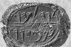
Biblical Arcaheological Review - 1 August 2008
A bulla, a lump of clay bearing a seal impression, inscribed with the name Gedalyahu ben Pashur has been found in the City of David excavations currently being conducted just south of Jerusalem’s Temple Mount. The find was announced by Eilat Mazar, who is leading the excavation; Mazar noted that the just-discovered bulla was found just yards from the spot where a bulaa inscribed with the name Yehukual ben Shelemyahu was unearthed three years ago. Both men served as ministers to King Zedekiah, the last ruler of the Kingdom of Judah before Jerusalem and its Temple were destroyed by the Babylonians in 587 B.C. According to Jeremiah 38:1-4, both men were part of a group that urged King Zedekiah to put Jeremiah to death because the prophet had preached that the besieged city of Jerusalem surrender to the Babylonians.
Mazar has been something of a controversial figure because she believes that a large stone structure she has been excavating had been the palace of King David. She has also suggested that a wall she has uncovered had been originally built by Nehemiah as part of the repairs to Jerusalem after the return from Babylonian exile.
Read about the Biblical-era seal in the Jerusalem Post.
Picture courtesy of Eilat Mazar
